Page Title
Lake Leschenaultia mountain bike trails
Lake Leschenaultia has a 12km mountain bike trail network, including 9 trails spanning 600m to 2.5km and ranging in difficulty from basic to intermediate.
The trails have been carefully designed to consider dieback mitigation, avoid native fauna habitats and to leave a minimal trail tread footprint.
- Railway Run: Easy, flat trail following the old miniature rail line. Ideal for beginners and children. 700m
- Man vs Machine: Long, technical climb for those who like a challenge. Intermediate skills required. Has been hand built. 1.5km
- Eastern Line: Easiest way to get to the top of the Trail Head. Basic skills required. 1.3km
- Yeehaa: Fast, flowy trail. Leads into the Woohoo trail. Intermediate skills required. 600m
- Hula: Flowy trail. Basic skills required. 1.4km
- Woohoo: Ramps and flow. Links to Yeehaa and Shakes n' Ladders. Intermediate skills required. 800m
- Shakes n' Ladders: Rock gardens and a north shore style ladder. Intermediate skills required. 1.3km
- Towies: Low jumps and flow. Leads to Stewies. Basic skills required. 700m
- Stewies: Introduction to Cross Country trails. Basic skills required. 1.8km
- Blue Panther: Old-school XC style. Intermediate skills required. 2.5km.
Mountain Bike Trail Course Map (PDF)
Watch the video below to see the mountain bike trails in action.
Pump track
Lake Leschenaultia has a fun pump track to play on where you can hone your skills.
Walking trails
Walk or cycle 3km around the Lake perimeter to view a range of native trees like marri and wandoo, together with an abundance of bird life including ducks, geese, herons and swamp hens.
There is also a 4km Cockatoo Trail loop walk within the reserve. This trail gently winds through the forest to the north of the lake and is particularly attractive during the wildflower season.
Orienteering
The following information has been provided by Orienteering Western Australia.
There are 4 standard line courses available for download:
- Easy: basic navigation, all on tracks with almost no climb (2.6km, 5m climb)
- Long Easy: some short cross-country shortcut options but all legs possible along tracks (4km, 45m climb)
- Moderate: some significant cross-country options (3.4km, 20m climb)
- Long Hard: the most demanding possible on this map (5.2km, 75m climb)
There is also a scatter course with all 20 controls.
Maps can be downloaded from the Anytime Orienteering website.
Please note:
- For individuals and small groups, no booking is required to use any of the orienteering courses. However, school and larger groups should contact the Perth Hills Mundaring Visitor Centre on 9290 6736 to ensure there are no conflicting activities scheduled for the area.
- The most suitable parking for those wishing to use the orienteering courses is east of the main entrance, as it is close to the main toilet block.
- The start and finish for all these courses is the large shelter between the park office/kiosk building and the main beach. Other starts could be used by anyone prepared to design their own course using the existing control sites shown on the 'all controls' scatter course map.
- The safety bearing on all courses is downhill to the lake.
Control markers
In the Lake Leschenaultia map area all control markers are attached to trees above head height, as close as possible to the designated feature control feature and in the direction given on the control descriptions.
The control marker is a 15cm square plate showing the number listed in the control descriptions and a 2-letter code. See photo below.
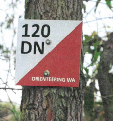
When you reach the control, write the letters in the numbered boxes on the map to show that you have visited the correct control.
Control marker number and letter codes
Control marker number and letter codes enable you to check whether the course was completed correctly.
Look for the control marker numbers on your course and check that you have the right letter code.
| Control Marker Number |
Letter Code |
| 101 |
AE |
| 102 |
KF |
| 103 |
JL |
| 104 |
OP |
| 105 |
TW |
| 106 |
YV |
| 107 |
ZU |
| 108 |
GH |
| 109 |
GI |
| 110 |
CD |
| 111 |
SX |
| 112 |
BR |
| 113 |
XN |
| 114 |
MP |
| 115 |
KJ |
| 116 |
FL |
| 117 |
WP |
| 118 |
OT |
| 119 |
YD |
| 120 |
GV |